Maps
| Name | Description | Project | Project Type | Document Date | Town |
|---|---|---|---|---|---|
|
|
DRI 764 MV Shipyard Workshop — Revised Area Land Use Map — 2024-8-31 | DRI | September 1, 2024 | ||
|
|
DRI 764 MV Shipyard Workshop — Area Land Use Map — 2024-8-26 | DRI | August 29, 2024 | ||
|
|
Potential Aquaculture Sites Sengekontacket Pond -- produced in 2024 as part of the MVP Eco-Resiliency grant. | Potential Aquaculture Sites | Planning Project | July 29, 2024 | Edgartown |
|
|
Potential Aquaculture Sites Sengekontacket Pond -- produced in 2024 as part of the MVP Eco-Resiliency grant. | Potential Aquaculture Sites | Planning Project | July 29, 2024 | Oak Bluffs |
|
|
Potential Aquaculture Sites Lagoon Pond -- produced in 2024 as part of the MVP Eco-Resiliency grant. | Potential Aquaculture Sites | Planning Project | July 29, 2024 | Oak Bluffs |
|
|
Potential Aquaculture Sites Lagoon Pond -- produced in 2024 as part of the MVP Eco-Resiliency grant. | Potential Aquaculture Sites | Planning Project | July 29, 2024 | Tisbury (Vineyard Haven) |
|
|
Potential Aquaculture Sites Tashmoo Pond -- produced in 2024 as part of the MVP Eco-resiliency grant. | Potential Aquaculture Siting | Planning Project | July 29, 2024 | Tisbury (Vineyard Haven) |
|
|
Map of Conservation Land displayed by Ownership. Map includes trails and parcel boundaries as of June 2023. | Other | June 28, 2023 | ||
|
|
TS_Connector_Roadway_Plan | Planning Project | July 26, 2024 | Tisbury (Vineyard Haven) | |
|
|
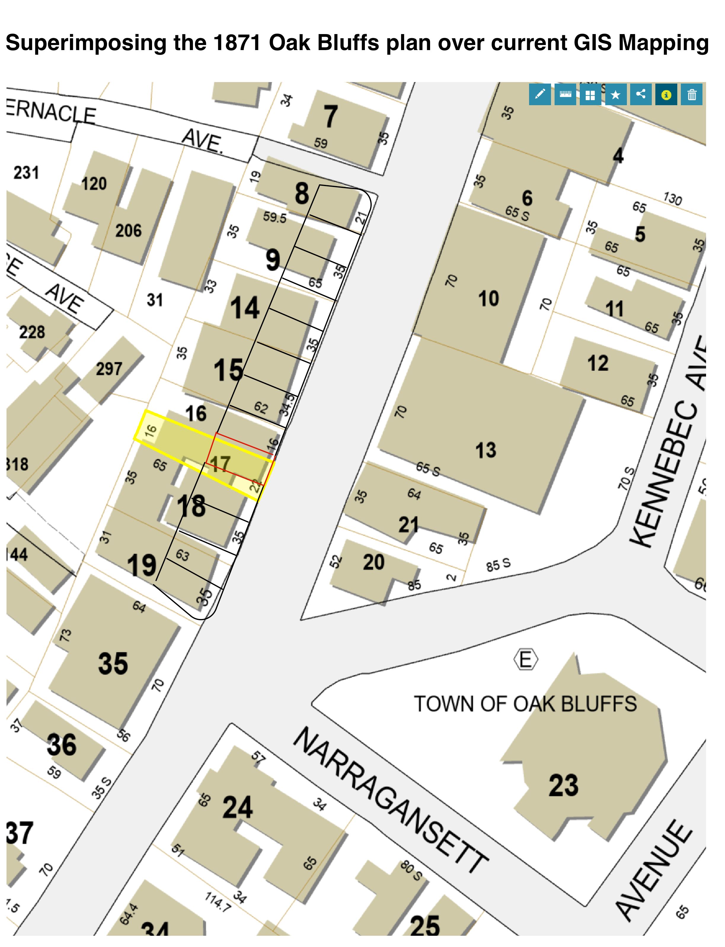
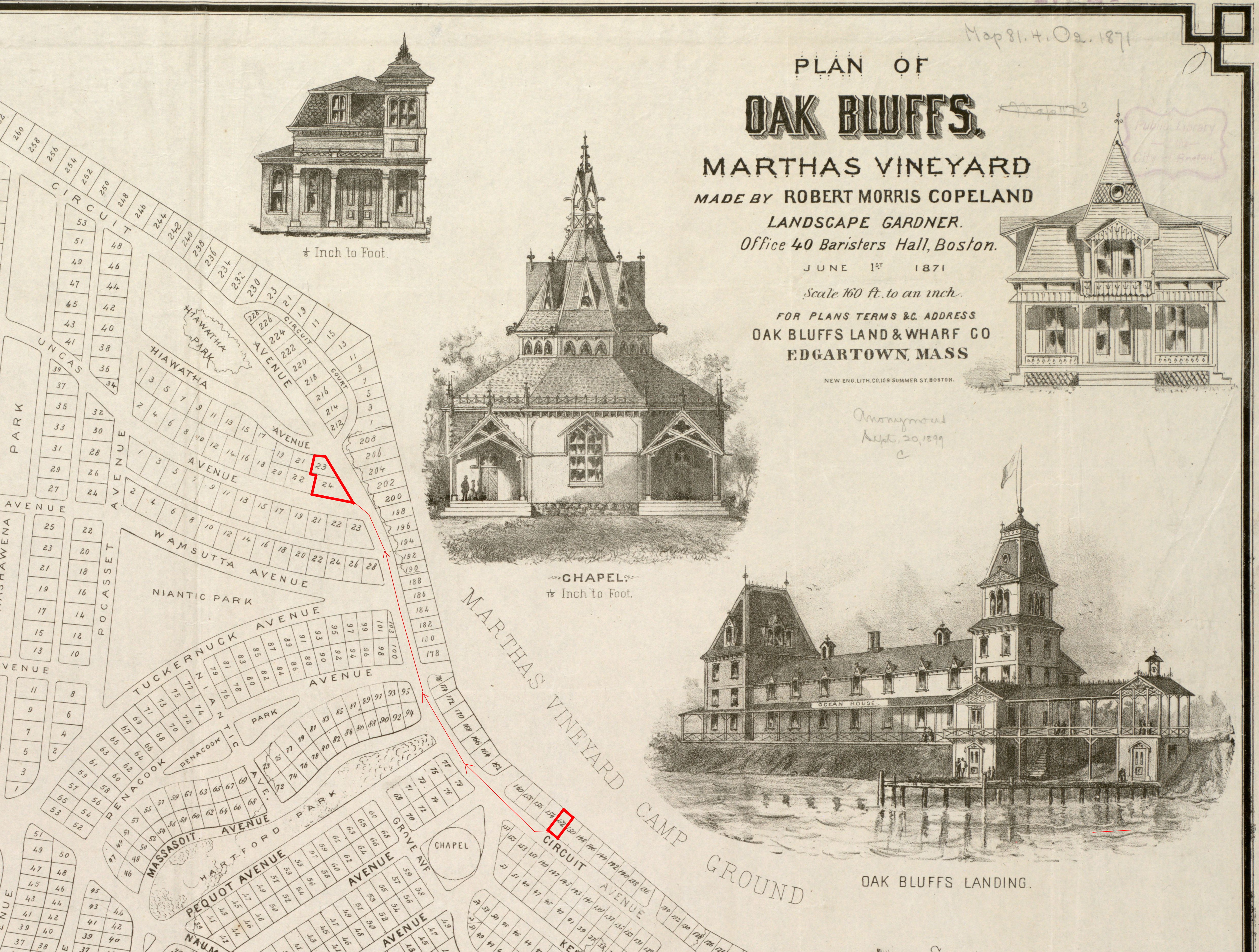
DRI 744 3 Uncas Avenue Historic Demolition & 40B Proposal — GIS Map/Historic Overlay/Ulwick Research — 2024-1-22 | DRI | January 25, 2024 | ||
|
|
DRI 744 3 Uncas Avenue Historic Demolition & 40B Proposal — Copeland Plan/Ulwick Research — 2024-1-22 | DRI | January 25, 2024 | ||
|
|
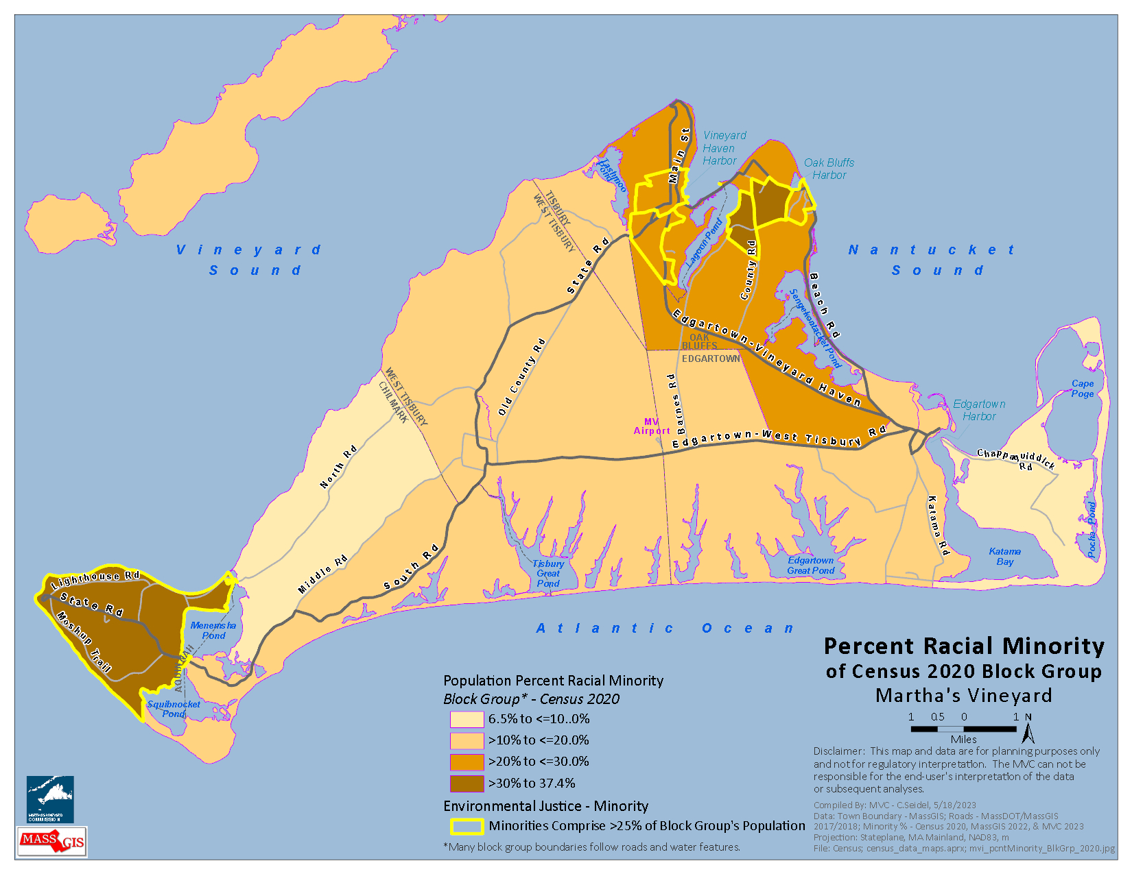
Map using the Census 2020 Block Group data showing the Percentage of the population within the racial minority. Map also includes the Environmental Justice (ethnic minority) community areas. This map was produced for the Regional Transportation Plan of 2023. | Other | December 6, 2023 | ||
|
|
Community Neighborhoods Initiative Grant Application Maps of 2023 | Other | December 6, 2023 | ||
|
|
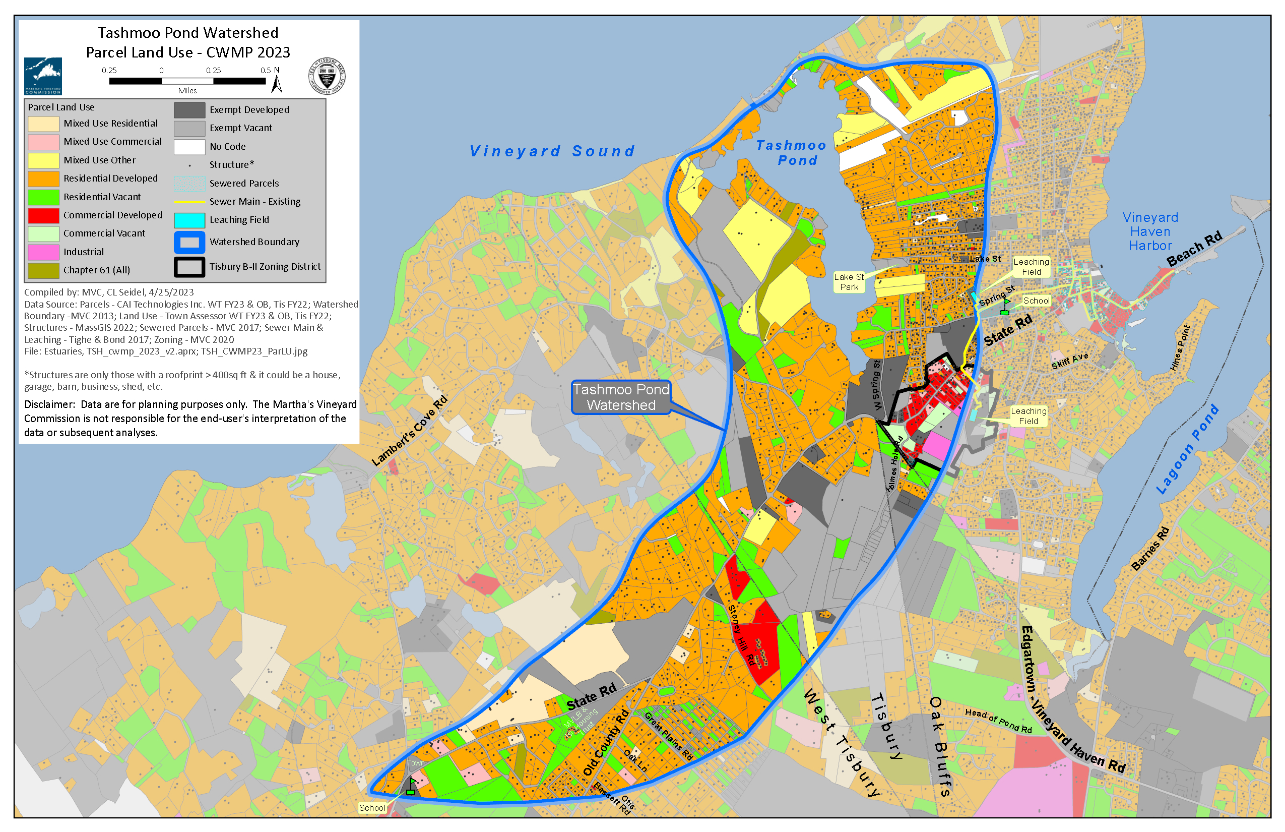
Map developed for the Comprehensive Wastewater Management Plan of Tashmoo Pond in 2023. Tisbury parcel data is FY22. | Other | April 27, 2023 | ||
|
|
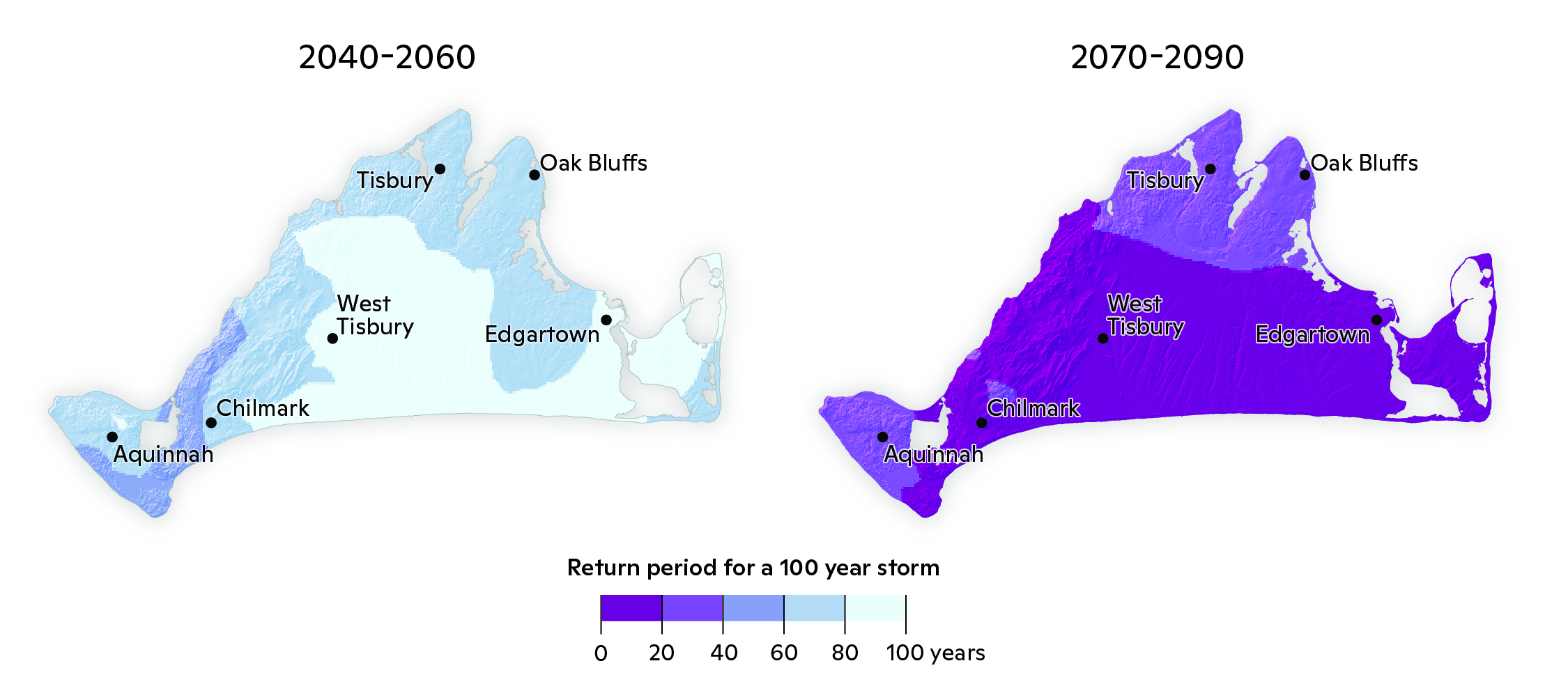
A map produced by the Woodwell Climate Research Center for the Vineyard's Climate Risk Assessment. The map shows the return period of the 100 year storm for two time future time periods. | Climate Risk Assessment MV | Planning Project | August 3, 2023 | All-Island |
|
|
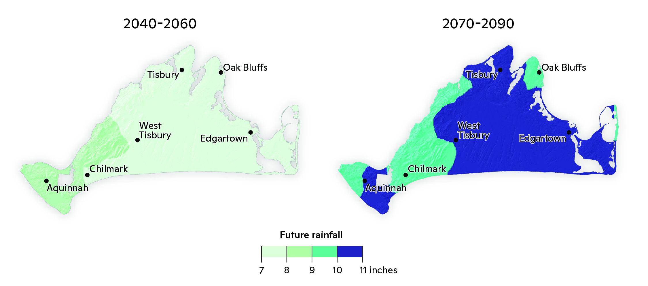
A map created by the Woodwell Climate Research Center showing future rainfall amounts for two time periods. | Climate Risk Assessment MV | Planning Project | August 3, 2023 | All-Island |
|
|
Links to STP final report and Center for Coastal Studies interactive mapping site. PDF file includes town-wide maps of STP. | Storm Tide Pathways | Planning Project | July 11, 2023 | All-Island |
|
|
Map compiled in Sept. 2022 with most current data available. The town of Aquinnah has several Overlay Zoning Districts. These districts have particular development regulations associated with them. See the town's zoning by-laws for specific details. The map is for planning purposes only and not for regulatory interpretation. The verbal delineation of the district's boundaries in the by-law take precedence over the visual map depiction. Overlay zoning bounds last updated in 2019. Parcel boundaries as of FY22. | Other | December 10, 2022 | ||
|
|
Map compiled in Sept. 2022 with most current data available. The town of Chilmark has several Overlay Zoning Districts. These districts have particular development regulations associated with them. See the town's zoning by-laws for specific details. The map is for planning purposes only and not for regulatory interpretation. The verbal delineation of the district's boundaries in the by-law take precedence over the visual map depiction. Overlay zoning bounds last updated in 2015. Parcel boundaries as of FY21. | Other | December 10, 2022 | ||
|
|
Map compiled in Sept. 2022 with most current data available. The town of Edgartown has several Overlay Zoning Districts. These districts have particular development regulations associated with them. See the town's zoning by-laws for specific details. The map is for planning purposes only and not for regulatory interpretation. The verbal delineation of the district's boundaries in the by-law take precedence over the visual map depiction. Overlay zoning bounds last updated in 2016. Parcel boundaries as of FY22. | Other | December 10, 2022 |
Pages
Office location:
Office location:
The Stone Building
33 New York Avenue
Oak Bluffs, MA 02557
Telephone: 508-693-3453
Fax: 508-693-7894
Mailing Address
Mailing address:
Martha's Vineyard Commission
P.O. Box 1447
Oak Bluffs, MA 02557
About the MVC
Site Map
Copyright
© 2008 - 2026
Martha's Vineyard Commission
All Rights Reserved