Maps
| Name | Description | Project | Project Type | Document Date | Town |
|---|---|---|---|---|---|
|
|
DCPC Coastal District Oak Bluffs map | DCPC | March 27, 2013 | Oak Bluffs | |
|
|
Water Resource Assessment Stations - Cape Poge - for sampling year 2004 | Other | October 18, 2006 | Edgartown | |
|
|
PDM Gosnold SLOSH map | Other | January 14, 2014 | Gosnold | |
|
|
DRI 549 Hart Hardware Watershed Map | hart hardware | DRI | December 8, 2006 | Oak Bluffs |
|
|
The map displays water resource assessment stations in Katama Bay where water quality samples were collected during 2007 | mv water quality survery: summer 2007 | Planning Project | June 18, 2009 | Edgartown |
|
|
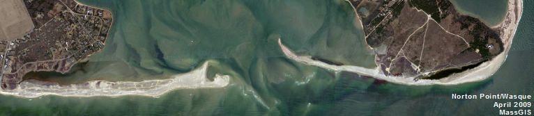
GPS collected shoreline & cliff data of Wasque point from June of 2012 overlayed on 2005 aerial photo. | wasque mapping | Planning Project | July 11, 2012 | Edgartown |
|
|
The map displays the water resource assessment stations in Chilmark Pond where water quality samples were collected during 2003. | mv water quality survey: summer 2003 | Planning Project | June 15, 2005 | Chilmark |
|
|
This map shows the preliminary flood zone data (released in June 2013 by FEMA). The data are displayed Island-wide and the distinction between the VE and AE Zones as well as the X (or 0.2% annual chance flood area) are displayed. | preliminary fema flood data | Planning Project | October 30, 2013 | All-Island |
|
|
Edgartown map created for the development vs conservation section of the Community Development Plan of 2004. | community development plan | Planning Project | October 23, 2006 | Edgartown |
|
|
Trail map of Katama Farm. | Other | June 23, 2014 | Edgartown | |
|
|
Island-Wide Map created for the open space and natural resources section of the Community Development Plan of 2004. | community development plan | Planning Project | October 27, 2006 | All-Island |
|
|
Zoning Map of Chilmark, MA. PDF format 11x17 page size, full color. Map compiled in Aug. 2007 but data still current as of July 2015. See the town by-law for more details. This map is for planning purposes only and not for regulatory interpretation. | zoning maps | Other | August 28, 2007 | Chilmark |
|
|
Tidal curves for all three ponds are shown recorded over a month long survey. | Other | September 8, 2010 | All-Island | |
|
|
land uses in the zone II for Tisbury | m.v. source water protection project | Planning Project | October 4, 2004 | Edgartown |
|
|
This document contains two maps - Map of Harbors, Ponds, & Ocean of MV and Map of Arterial and Collector Roads of MV. These maps are for DRI Checklist Items 5.1 & 7.1, respectively (per DRI Checklist of May 2013). This map is to assist with identifying if a proposed project falls within a geographic trigger area. If so, the user must then refer to the DRI Checklist to determine if the project must be referred to the Martha's Vineyard Commission for review. | Other | April 11, 2013 | All-Island | |
|
|
Water Resource Assessment Stations - Pocha Pond - for sampling year 2004 | Other | October 18, 2006 | Edgartown | |
|
|
PDM Gosnold Sea Level Rise Map | Other | January 14, 2014 | Gosnold | |
|
|
Edgartown map created for the Development vs Conservation section of the Community Development Plan of 2004. | community development plan | Planning Project | October 23, 2006 | Edgartown |
|
|
DRI 549 Hart Site and Landscape Plan | hart hardware | DRI | December 8, 2006 | West Tisbury |
|
|
The map displays water resource assessment station in Oyster Pond where water quality samples were collected during 2007 | mv water quality survery: summer 2007 | Planning Project | June 18, 2009 | Edgartown |
Pages
Office location:
Office location:
The Stone Building
33 New York Avenue
Oak Bluffs, MA 02557
Telephone: 508-693-3453
Fax: 508-693-7894
Mailing Address
Mailing address:
Martha's Vineyard Commission
P.O. Box 1447
Oak Bluffs, MA 02557
About the MVC
Site Map
Copyright
© 2008 - 2025
Martha's Vineyard Commission
All Rights Reserved