Maps
| Name | Description | Project | Project Type | Document Date | Town |
|---|---|---|---|---|---|
|
|
land uses in the Lagoon Pond-State Forest Zone II, Town of Oak Bluffs | m. v. source water protection project | Planning Project | October 4, 2004 | Oak Bluffs |
|
|
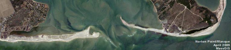
In June of 2012, some of the high tide line and cliff at Wasque Point was GPSed by the MVC. This data was then placed into Google Earth and overlayed on the various aerial photos available thru Google Earth (time span 1991 - 2012). | wasque mapping | Planning Project | July 11, 2012 | Edgartown |
|
|
Water Resource Assessment Stations - Lagoon Pond - for sampling year 2004 | Other | October 18, 2006 | Oak Bluffs | |
|
|
PDM Edgartown Sea Level Rise map | Other | January 14, 2014 | Edgartown | |
|
|
Island-wide map created for the Open Space and Natural Resources section of the Community Development Plan of 2004. | community development plan | Planning Project | October 27, 2006 | All-Island |
|
|
Parcels (as of 2008) overlaid on FEMA's 100 year and 500 year flood zones (as of 2010). | Other | February 7, 2013 | Aquinnah (Gay Head) | |
|
|
Zoning Map of Oak Bluffs, MA. PDF format 11x17 page size, full color. Map compiled in Nov. 2014 but data still current as of July 2015. See the town by-law for more details. This map is for planning purposes only and not for regulatory interpretation. | zoning maps | Other | November 25, 2014 | Oak Bluffs |
|
|
Sengekontacket Pond water quality sampling stations for resource assessment during 2003 | mv coastal pond water quality survey: summer 2003 | Planning Project | June 15, 2005 | Edgartown |
|
|
DCPC Coastal District Oak Bluffs map | DCPC | March 27, 2013 | Oak Bluffs | |
|
|
The hurricane surge inundation areas shown on this map depict the inundation that can be expected to result from a worst case combination of hurricane landfall location, forward speed, and direction for each hurricane category. | Other | July 5, 2013 | West Tisbury | |
|
|
Edgartown map created for the Housing Suitability Analysis section of the Community Development Plan of 2004. | community development plan | Planning Project | October 27, 2006 | Edgartown |
|
|
Trustees of Reservations property map for Wasque & Cape Poge Reservations. | Other | April 3, 2014 | Edgartown | |
|
|
The map displays water resource assessment stations in Katama Bay where water quality samples were collected during 2007 | mv water quality survery: summer 2007 | Planning Project | June 18, 2009 | Edgartown |
|
|
DRI 601 GIS Locus Map | karakul/cannada | DRI | February 22, 2007 | Edgartown |
|
|
land uses in the Zone II for the Farm Neck well, Oak Bluffs Water District | m.v. source water protection project | Planning Project | October 4, 2004 | Oak Bluffs |
|
|
GPS collected shoreline & cliff data of Wasque point from June of 2012 overlayed on 2005 aerial photo. | wasque mapping | Planning Project | July 11, 2012 | Edgartown |
|
|
Island-wide map created for the economic suitability section of the Community Development Plan of 2004. | community development plan | Planning Project | October 23, 2006 | All-Island |
|
|
PDM Gosnold FIRM map | Other | January 14, 2014 | Gosnold | |
|
|
Island-wide map created for the open space and natural resources section of the Community Development plan of 2004. | community development plan | Planning Project | October 27, 2006 | All-Island |
|
|
Island-wide map created for the economic section of the community development plan of 2004. | community development plan | Planning Project | October 27, 2006 | All-Island |
Pages
Office location:
Office location:
The Stone Building
33 New York Avenue
Oak Bluffs, MA 02557
Telephone: 508-693-3453
Fax: 508-693-7894
Mailing Address
Mailing address:
Martha's Vineyard Commission
P.O. Box 1447
Oak Bluffs, MA 02557
About the MVC
Site Map
Copyright
© 2008 - 2025
Martha's Vineyard Commission
All Rights Reserved