Maps
| Name | Description | Project | Project Type | Document Date | Town |
|---|---|---|---|---|---|
|
|
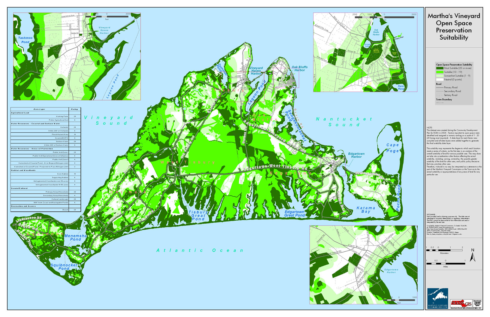
This dataset was created during the Community Development Plan for EOEA in 2004. Factors important to open space were identified and assigned a numeric ranking on a scale of 1 to 20 (20 being most important). A data layer for each factor was compiled and all data layers were added together to generate this final suitability data layer. | community development plan | Planning Project | October 4, 2006 | All-Island |
|
|
DRI 549 Hart Site and Landscape Plan | hart hardware | DRI | December 8, 2006 | West Tisbury |
|
|
The map displays water resource assessment station in Oyster Pond where water quality samples were collected during 2007 | mv water quality survery: summer 2007 | Planning Project | June 18, 2009 | Edgartown |
|
|
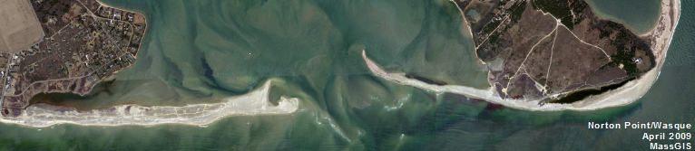
GPS collected shoreline & cliff data of Wasque point from June of 2012 overlayed on 2009 aerial photo. | wasque mapping | Planning Project | July 11, 2012 | Edgartown |
|
|
In delivering the preliminary FIRMs (Flood Insurance Rate Map), FEMA sectioned Dukes County into 68 'tiles'. This map is the index map showing the tile bounding area and corresponding index number for all the tiles within Dukes County. | Other | October 30, 2013 | Gosnold | |
|
|
Environmental Sensitivity Index Map Squibnocket Quadrangle | sensitivity of coastal environments and wildlife to spilled oil | Planning Project | February 25, 2005 | Aquinnah (Gay Head) |
|
|
Map showing suggested bike route from ferry terminals. | Other | June 25, 2014 | Oak Bluffs | |
|
|
Island-wide map created for the housing section of the Community Development Plan of 2004. | community development plan | Planning Project | October 27, 2006 | All-Island |
|
|
Edgartown map created for the existing conditions section of the Community Development Plan of 2004. | community development plan | Planning Project | October 23, 2006 | Edgartown |
|
|
Zoning Map of Chilmark, MA. PDF format 11x17 page size, full color. Map compiled in Aug. 2007 but data still current as of July 2015. See the town by-law for more details. This map is for planning purposes only and not for regulatory interpretation. | zoning maps | Other | August 28, 2007 | Chilmark |
|
|
Tidal curves for all three ponds are shown recorded over a month long survey. | Other | September 8, 2010 | All-Island | |
|
|
This document contains two maps - Map of Harbors, Ponds, & Ocean of MV and Map of Arterial and Collector Roads of MV. These maps are for DRI Checklist Items 5.1 & 7.1, respectively (per DRI Checklist of May 2013). This map is to assist with identifying if a proposed project falls within a geographic trigger area. If so, the user must then refer to the DRI Checklist to determine if the project must be referred to the Martha's Vineyard Commission for review. | Other | April 11, 2013 | All-Island | |
|
|
Other | July 9, 2004 | |||
|
|
PDM Gosnold Sea Level Rise Map | Other | January 14, 2014 | Gosnold | |
|
|
Edgartown map created for the Development vs Conservation section of the Community Development Plan of 2004. | community development plan | Planning Project | October 23, 2006 | Edgartown |
|
|
Map showing NHESP Priority Habitats of Rare Species and NHESP Estimated Habitats of Rare Wildlife. These data are effective as of Oct. 1, 2006. | Other | October 4, 2006 | Gosnold | |
|
|
DRI 601 Assessor's Locus Map | karakul/cannada | DRI | February 22, 2007 | Edgartown |
|
|
The map displays water resource assessment stations in Tisbury Great Pond where water quality samples were collected during 2007 | mv water quality survery: summer 2007 | Planning Project | June 18, 2009 | West Tisbury |
|
|
GPS collected shoreline & cliff data of Wasque point from June of 2012 overlayed on 2011 aerial photo. | wasque mapping | Planning Project | July 11, 2012 | Edgartown |
|
|
This map displays the DCPC (Districts of Critical Planning Concern) and other overlay zoning areas for Oak Bluffs, MA. Last updated on 11/7/14. Note: This version does NOT include the Water Resource Protection District. This data will be included in a future version of this map. | Other | November 7, 2014 | Oak Bluffs |
Pages
Office location:
Office location:
The Stone Building
33 New York Avenue
Oak Bluffs, MA 02557
Telephone: 508-693-3453
Fax: 508-693-7894
Mailing Address
Mailing address:
Martha's Vineyard Commission
P.O. Box 1447
Oak Bluffs, MA 02557
About the MVC
Site Map
Copyright
© 2008 - 2025
Martha's Vineyard Commission
All Rights Reserved