Maps
| Name | Description | Project | Project Type | Document Date | Town |
|---|---|---|---|---|---|
|
|
DRI 601 GIS Locus Map | karakul/cannada | DRI | February 22, 2007 | Edgartown |
|
|
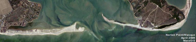
GPS collected shoreline & cliff data of Wasque point from June of 2012 overlayed on 2009 aerial photo. | wasque mapping | Planning Project | July 11, 2012 | Edgartown |
|
|
Edgartown town map created for the existing conditions section of the Community Development Plan of 2004 | community development plan | Planning Project | October 23, 2006 | Edgartown |
|
|
In delivering the preliminary FIRMs (Flood Insurance Rate Map), FEMA sectioned Dukes County into 68 'tiles'. This map is the index map showing the tile bounding area and corresponding index number for all the tiles within Dukes County. | Other | October 30, 2013 | Gosnold | |
|
|
Map showing suggested bike route from ferry terminals. | Other | June 25, 2014 | Oak Bluffs | |
|
|
Island-wide map created for the economic section of the community development plan of 2004. | community development plan | Planning Project | October 27, 2006 | All-Island |
|
|
Land use maps for the three watersheds | Other | September 8, 2010 | All-Island | |
|
|
Tashmoo Pond water quality sampling stations for resource assessment during 2003 | mv coastal pond water quality survey- summer 2003 | Planning Project | June 15, 2005 | Tisbury (Vineyard Haven) |
|
|
Zoning Map of Tisbury, MA. PDF format 11x17 page size, full color. Map compiled in Aug. 2007 but data still current as of July 2015. See the town by-law for more details. This map is for planning purposes only and not for regulatory interpretation. | zoning maps | Other | August 28, 2007 | Tisbury (Vineyard Haven) |
|
|
PDM Gosnold Wildland-urban Interface Map | Other | January 14, 2014 | Gosnold | |
|
|
Edgartown map created for the economic suitability section of the Community Development Plan of 2004. | community development plan | Planning Project | October 23, 2006 | Edgartown |
|
|
The map displays water resource assessment stations in Tisbury Great Pond where water quality samples were collected during 2007 | mv water quality survery: summer 2007 | Planning Project | June 18, 2009 | West Tisbury |
|
|
land uses within the Machacket-Lily Zone II, Town of Edgartown | m. v. source water protection project | Planning Project | October 4, 2004 | Edgartown |
|
|
DRI 593 Aerial Overview | 18 state road | DRI | March 28, 2007 | Tisbury (Vineyard Haven) |
|
|
GPS collected shoreline & cliff data of Wasque point from June of 2012 overlayed on 2011 aerial photo. | wasque mapping | Planning Project | July 11, 2012 | Edgartown |
|
|
Edgartown map created for the existing conditions section of the Community Development Plan of 2004. | community development plan | Planning Project | October 23, 2006 | Edgartown |
|
|
This map displays the DCPC (Districts of Critical Planning Concern) and other overlay zoning areas for Oak Bluffs, MA. Last updated on 11/7/14. Note: This version does NOT include the Water Resource Protection District. This data will be included in a future version of this map. | Other | November 7, 2014 | Oak Bluffs | |
|
|
Using various data sources (conservation land, wetlands, and assessor's data) the MVC compiled a dataset which identifies land on Martha's Vineyard as either fully developed, conserved, fully available, or partially available for development. Updated in 2014. | Other | September 17, 2014 | All-Island | |
|
|
Island-wide map created for the housing section of the Community Development Plan of 2004. | community development plan | Planning Project | October 27, 2006 | All-Island |
|
|
Parcels (as of 2008) overlaid on FEMA's 100 year and 500 year flood zones (as of 2010). | Other | February 7, 2013 | Oak Bluffs |
Pages
Office location:
Office location:
The Stone Building
33 New York Avenue
Oak Bluffs, MA 02557
Telephone: 508-693-3453
Fax: 508-693-7894
Mailing Address
Mailing address:
Martha's Vineyard Commission
P.O. Box 1447
Oak Bluffs, MA 02557
About the MVC
Site Map
Copyright
© 2008 - 2026
Martha's Vineyard Commission
All Rights Reserved