Maps
| Name | Description | Project | Project Type | Document Date | Town |
|---|---|---|---|---|---|
|
|
Zoning Map of Oak Bluffs, MA. PDF format 11x17 page size, full color. Map compiled in Nov. 2014 but data still current as of July 2015. See the town by-law for more details. This map is for planning purposes only and not for regulatory interpretation. | zoning maps | Other | November 25, 2014 | Oak Bluffs |
|
|
Pocha Pond water quality sampling stations for water resource assessment during 2003 | mv coastal pond water quality survey- summer 2003 | Planning Project | June 15, 2005 | Edgartown |
|
|
Map of bike route segments from Lagoon Pond drawbridge to VH SSA terminial | Planning Project | September 16, 2012 | Tisbury (Vineyard Haven) | |
|
|
This map was compiled by the MVC for the 2015 Hazard Mitigation Plan. Depicted here are the Hurricane Surge Inundation (Flooded) Areas per the SLOSH Model (data released in Spring of 2013 by USACE). The map also includes the 100 year flood zone from the Preliminary dFIRM data released by FEMA in June of 2013. | Other | March 27, 2014 | West Tisbury | |
|
|
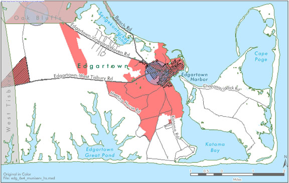
Edgartown map created for the Housing Suitability Analysis section of the Community Development Plan of 2004. | community development plan | Planning Project | October 27, 2006 | Edgartown |
|
|
DRI 601 GIS Locus Map | karakul/cannada | DRI | February 22, 2007 | Edgartown |
|
|
Environmental Sensitivity Index Map Naushon Island | sensitivity of coastal environments and wildlife to spilled oil | Planning Project | February 25, 2005 | Chilmark |
|
|
Hurricane inundation areas overlayed on parcel boundaries and aerial photo from 2009. | Other | August 26, 2011 | Oak Bluffs | |
|
|
PDM Edgartown Wildland-urban Interface Map | Other | January 14, 2014 | Edgartown | |
|
|
Edgartown map created for the existing conditions section of the Community Development Plan of 2004. | community development plan | Planning Project | October 23, 2006 | Edgartown |
|
|
Island-wide map created for the economic section of the community development plan of 2004. | community development plan | Planning Project | October 27, 2006 | All-Island |
|
|
This map was created by displaying the latest elevation data (<1m in red & 1-2m in orange). No special modeling was done to account for future changes in shoreline. The map uses the USGS topo from the mid-1970s as a basemap. | Other | February 10, 2010 | Tisbury (Vineyard Haven) | |
|
|
The hurricane surge inundation areas shown on this map depict the inundation that can be expected to result from a worst case combination of hurricane landfall location, forward speed, and direction for each hurricane category. | Other | July 5, 2013 | Tisbury (Vineyard Haven) | |
|
|
Zoning Map of Tisbury, MA. PDF format 11x17 page size, full color. Map compiled in Aug. 2007 but data still current as of July 2015. See the town by-law for more details. This map is for planning purposes only and not for regulatory interpretation. | zoning maps | Other | August 28, 2007 | Tisbury (Vineyard Haven) |
|
|
Water Resource Assessment Stations - Chilmark Pond - for sampling year 2004 | 604b04 | Planning Project | September 29, 2006 | Chilmark |
|
|
wildland urban interface map | Planning Project | October 18, 2012 | Gosnold | |
|
|
Trail map, created by The Nature Conservancy, of their Hoft Farm property. | Other | April 3, 2014 | Tisbury (Vineyard Haven) | |
|
|
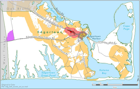
Edgartown map created for the economic suitability section of the Community Development Plan of 2004. | community development plan | Planning Project | October 23, 2006 | Edgartown |
|
|
The map displays the water resource assessment stations in Katama Bay where water quality samples were collected during 2006. | mv water quality survey: summer 2006 | Planning Project | July 14, 2008 | Edgartown |
|
|
DRI 593 Aerial Overview | 18 state road | DRI | March 28, 2007 | Tisbury (Vineyard Haven) |
Pages
Office location:
Office location:
The Stone Building
33 New York Avenue
Oak Bluffs, MA 02557
Telephone: 508-693-3453
Fax: 508-693-7894
Mailing Address
Mailing address:
Martha's Vineyard Commission
P.O. Box 1447
Oak Bluffs, MA 02557
About the MVC
Site Map
Copyright
© 2008 - 2026
Martha's Vineyard Commission
All Rights Reserved