Maps
| Name | Description | Project | Project Type | Document Date | Town |
|---|---|---|---|---|---|
|
|
Major watershed boundaries (adopted by MVC in Nov. 2015). The watershed boundaries were compiled through the MassEstuaries program work conducted by SMAST and the MVC. The boundaries are based on hydrology, geology, and topography. Boundaries were initially created using a computer model (performed by SMAST) and then modified with on-screen digitizing (performed by SMAST &/or MVC) if warranted by additional data. | Other | November 19, 2015 | All-Island | |
|
|
Major watershed boundaries (adopted by MVC in Nov. 2015). The watershed boundaries were compiled through the MassEstuaries program work conducted by SMAST and the MVC. The boundaries are based on hydrology, geology, and topography. Boundaries were initially created using a computer model (performed by SMAST) and then modified with on-screen digitizing (performed by SMAST &/or MVC) if warranted by additional data. | Other | January 4, 2016 | All-Island | |
|
|
Major watershed boundaries (adopted by MVC in Nov. 2015). The watershed boundaries were compiled through the MassEstuaries program work conducted by SMAST and the MVC. The boundaries are based on hydrology, geology, and topography. Boundaries were initially created using a computer model (performed by SMAST) and then modified with on-screen digitizing (performed by SMAST &/or MVC) if warranted by additional data. | Other | November 19, 2015 | All-Island | |
|
|
A document with thumbnail images of the most current Watershed Maps for the County of Dukes County. Each thumbnail image is hotlinked to the respective PDF map document in the MVC's Resource Center. The PDF map can be viewed, printed, or downloaded. | Other | January 11, 2016 | ||
|
|
Major watershed boundaries (data last updated in 2014 & and still current as of 11/13/15). The watershed boundaries were compiled through the MassEstuaries program work conducted by SMAST and the MVC. The boundaries are based on hydrology, geology, and topography. Boundaries were initially created using a computer model (performed by SMAST) and then modified with on-screen digitizing (performed by SMAST &/or MVC) if warranted by additional data. | Other | November 13, 2015 | All-Island | |
|
|
A document with thumbnail images of the most current Road Maps for the County of Dukes County. Each thumbnail image is hotlinked to the respective PDF map document in the MVC's Resource Center. The PDF map can be viewed, printed, or downloaded. | Other | January 11, 2016 | ||
|
|
A document with thumbnail images of the most current Zoning Maps for the County of Dukes County. Each thumbnail image is hotlinked to the respective PDF map document in the MVC's Resource Center. The PDF map can be viewed, printed, or downloaded. | Other | January 11, 2016 | ||
|
|
This map shows the zoning boundaries within the town of Gosnold, MA. Overlayed on the zoning are the parcel property boundaries. This information is provided for planning purposes only. Regulation property bounds must be determined by a licensed surveyor. The written legal description of the zoning boundaries takes precedence over the visual displayed on the map. | Other | November 9, 2015 | ||
|
|
Not the most current maps as of Dec. 2022. This map shows the zoning boundaries within the town of West Tisbury, MA. Overlayed on the zoning are the parcel property boundaries. This information is provided for planning purposes only. Regulation property bounds must be determined by a licensed surveyor. The written legal description of the zoning boundaries takes precedence over the visual displayed on the map. | Other | November 9, 2015 | ||
|
|
Not the most current map as of Dec. 2022. This map shows the zoning boundaries within the town of Tisbury, MA. Overlayed on the zoning are the parcel property boundaries. This information is provided for planning purposes only. Regulation property bounds must be determined by a licensed surveyor. The written legal description of the zoning boundaries takes precedence over the visual displayed on the map. | Other | November 9, 2015 | ||
|
|
Not the most current map as of Dec. 2022. This map shows the zoning boundaries within the town of Oak Bluffs, MA. Overlayed on the zoning are the parcel property boundaries. This information is provided for planning purposes only. Regulation property bounds must be determined by a licensed surveyor. The written legal description of the zoning boundaries takes precedence over the visual displayed on the map. | Other | November 9, 2015 | ||
|
|
Not the most current map as of Dec. 2022. This map shows the zoning boundaries within the town of Edgartown, MA. Overlayed on the zoning are the parcel property boundaries. This information is provided for planning purposes only. Regulation property bounds must be determined by a licensed surveyor. The written legal description of the zoning boundaries takes precedence over the visual displayed on the map. | Other | January 4, 2016 | ||
|
|
Not the most current map as of Dec. 2022. This map shows the zoning boundaries within the town of Chilmark, MA. Overlayed on the zoning are the parcel property boundaries. This information is provided for planning purposes only. Regulation property bounds must be determined by a licensed surveyor. The written legal description of the zoning boundaries takes precedence over the visual displayed on the map. | Other | November 9, 2015 | ||
|
|
Not the most current map as of Dec. 2022. This map shows the zoning boundaries within the town of Aquinnah, MA. Overlayed on the zoning are the parcel property boundaries. This information is provided for planning purposes only. Regulation property bounds must be determined by a licensed surveyor. The written legal description of the zoning boundaries takes precedence over the visual displayed on the map. | Other | November 9, 2015 | ||
|
|
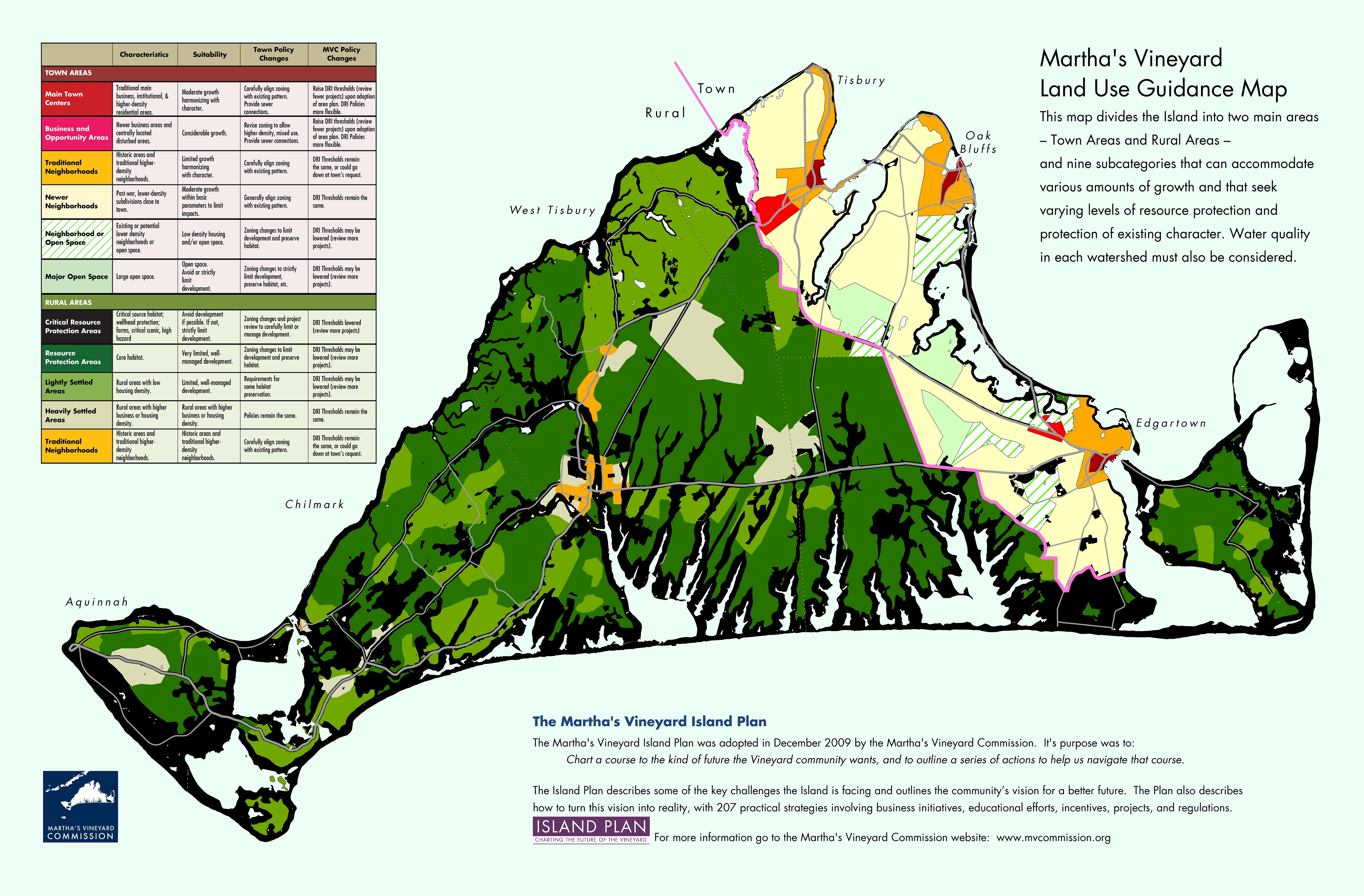
The Martha's Vineyard Island Plan's main recommendations are summarized in the Land Use Guidance Map. This vision map divides the Island into two main areas - Town Areas and Rural Areas - and nine subcategories that can accommodate various amounts of growth and that seek varying levels of resource protection and protection of existing character. We'll be displaying a new map every month or so to highlight the work of the Commission. | island plan | Planning Project | October 22, 2015 | All-Island |
|
|
Graphic produced by GPI showing a proposed re-design improvement for Beach Road in Vineyard Haven. This version was created on 09/08/15. | Beach Road Improvement | Planning Project | September 8, 2015 | Tisbury (Vineyard Haven) |
|
|
This map displays the DCPC (Districts of Critical Planning Concern) and other overlay zoning areas for West Tisbury, MA. Last updated on 7/30/15. | Other | July 30, 2015 | Oak Bluffs | |
|
|
This map displays the DCPC (Districts of Critical Planning Concern) and other overlay zoning areas for Aquinnah, MA. Last updated on 7/30/15. | Other | July 30, 2015 | Oak Bluffs |
Pages
Office location:
Office location:
The Stone Building
33 New York Avenue
Oak Bluffs, MA 02557
Telephone: 508-693-3453
Fax: 508-693-7894
Mailing Address
Mailing address:
Martha's Vineyard Commission
P.O. Box 1447
Oak Bluffs, MA 02557
About the MVC
Site Map
Copyright
© 2008 - 2026
Martha's Vineyard Commission
All Rights Reserved