Maps
| Name | Description | Project | Project Type | Document Date | Town |
|---|---|---|---|---|---|
|
|
Other | July 23, 2004 | All-Island | ||
|
|
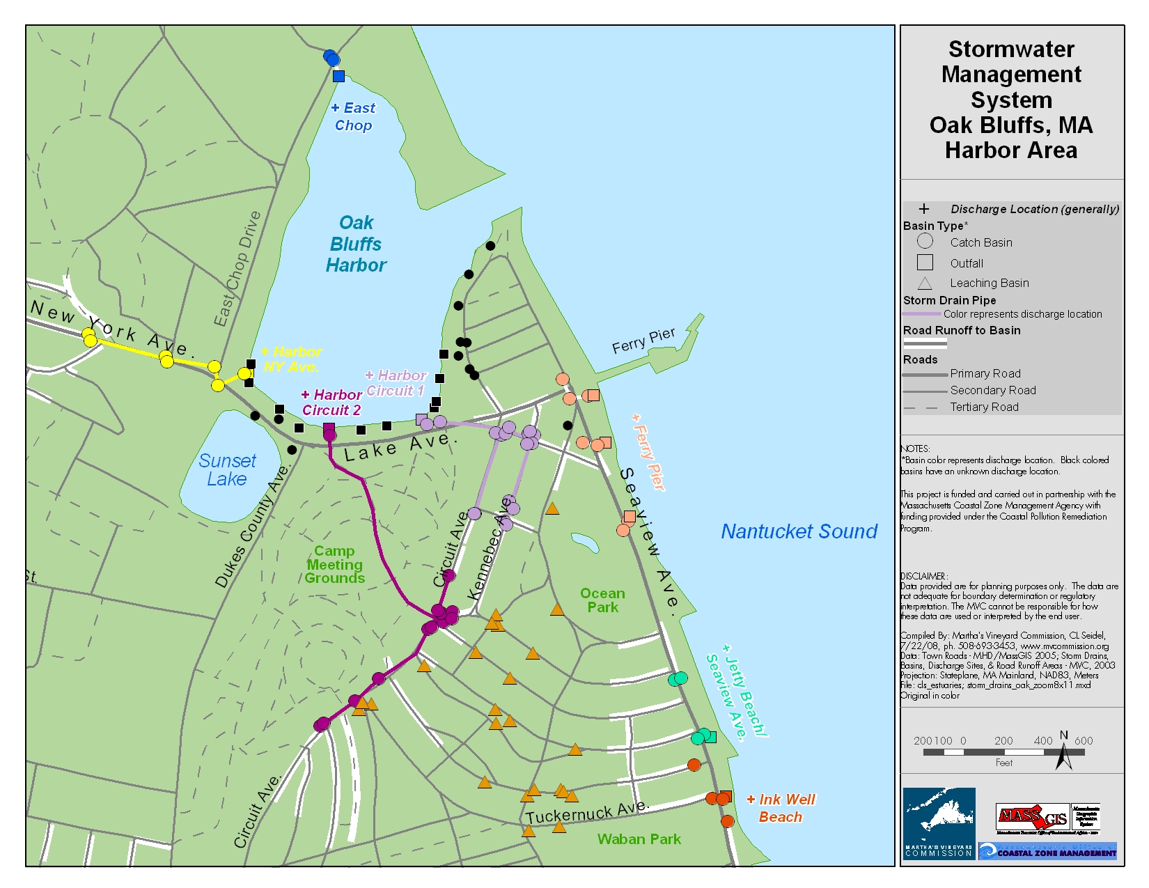
Catch basin locations were GPSed by the MVC. The general storm water pipeline system is also mapped. This map is formatted for an 8x11 page. | Planning Project | January 7, 2015 | Oak Bluffs | |
|
|
Water Resource Assessment Stations - Farm Pond - for sampling year 2004 | Other | October 18, 2006 | Oak Bluffs | |
|
|
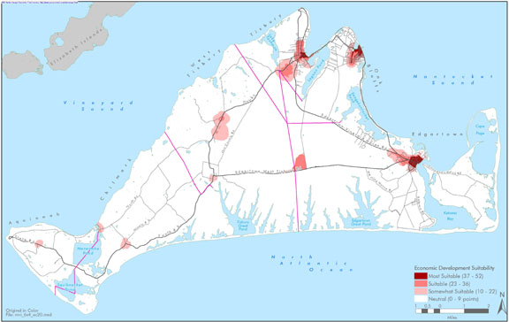
Island-wide map created for the economic section of the Community Development Plan of 2004. | community development plan | Planning Project | October 27, 2006 | All-Island |
|
|
The map displays water resource assessment stations in Katama Bay where water quality samples were collected during 2007 | mv water quality survery: summer 2007 | Planning Project | June 18, 2009 | Edgartown |
|
|
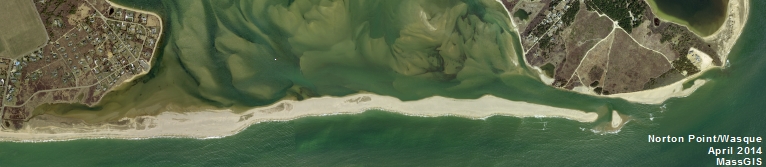
GPS collected shoreline & cliff data of Wasque point from June of 2012 overlayed on 2005 aerial photo. | wasque mapping | Planning Project | July 11, 2012 | Edgartown |
|
|
PDM Aquinnah SLOSH map | Other | January 14, 2014 | ||
|
|
DRI 584 - Cozy Hearth Plot Plan | cozy hearth | DRI | May 12, 2005 | Edgartown |
|
|
Edgartown map created for the open space & natural resources section of the Community Development Plan of 2004. | community development plan | Planning Project | October 23, 2006 | Edgartown |
|
|
Edgartown map created for the housing section of the Community Development Plan of 2004. | community development plan | Planning Project | October 23, 2006 | Edgartown |
|
|
James Pond water quality sampling stations for resource assessment during 2005 | mv coastal pond water quality survey- summer 2005 | Planning Project | June 22, 2007 | West Tisbury |
|
|
Parcels (as of 2008) overlaid on FEMA's 100 year and 500 year flood zones (as of 2010). | Other | February 7, 2013 | Aquinnah (Gay Head) | |
|
|
PDM Tisbury FIRM | pdm | Other | January 8, 2014 | Tisbury (Vineyard Haven) |
|
|
This document contains two maps - Map of Harbors, Ponds, & Ocean of MV and Map of Arterial and Collector Roads of MV. These maps are for DRI Checklist Items 5.1 & 7.1, respectively (per DRI Checklist of May 2013). This map is to assist with identifying if a proposed project falls within a geographic trigger area. If so, the user must then refer to the DRI Checklist to determine if the project must be referred to the Martha's Vineyard Commission for review. | Other | April 11, 2013 | All-Island | |
|
|
Color map - E size | Other | July 23, 2004 | Oak Bluffs | |
|
|
Catch basin locations were GPSed by the MVC. The general storm water pipeline system is also mapped. This map is formatted for an 8x11 page. | Planning Project | January 7, 2015 | Tisbury (Vineyard Haven) | |
|
|
Water Resource Assessment Stations - Tashmoo Pond - for sampling year 2004 | Other | October 18, 2006 | Tisbury (Vineyard Haven) | |
|
|
Island-wide map created for the housing section of the Community Development Plan of 2004. | community development plan | Planning Project | October 27, 2006 | All-Island |
|
|
The map displays water resource assessment station in Oyster Pond where water quality samples were collected during 2007 | mv water quality survery: summer 2007 | Planning Project | June 18, 2009 | Edgartown |
|
|
GPS collected shoreline & cliff data of Wasque point from June of 2012 overlayed on 2009 aerial photo. | wasque mapping | Planning Project | July 11, 2012 | Edgartown |
Pages
Office location:
Office location:
The Stone Building
33 New York Avenue
Oak Bluffs, MA 02557
Telephone: 508-693-3453
Fax: 508-693-7894
Mailing Address
Mailing address:
Martha's Vineyard Commission
P.O. Box 1447
Oak Bluffs, MA 02557
About the MVC
Site Map
Copyright
© 2008 - 2026
Martha's Vineyard Commission
All Rights Reserved