Maps
| Name | Description | Project | Project Type | Document Date | Town |
|---|---|---|---|---|---|
|
|
Oyster Pond water quality sampling stations for resource assessment during 2005 | mv coastal pond water quality survey- summer 2005 | Other | June 22, 2007 | Edgartown |
|
|
Environemntal Sensitivity Index Map Tisbury Great Pond Quadrangle | sensitivity of coastal environments and wildlife to spilled oil | Planning Project | February 25, 2005 | Chilmark |
|
|
Edgartown map created for the existing conditions section of the Community Development Plan of 2004. | community development plan | Planning Project | October 23, 2006 | Edgartown |
|
|
Parcels (as of 2008) overlaid on FEMA's 100 year and 500 year flood zones (as of 2010). | Other | February 7, 2013 | Oak Bluffs | |
|
|
PDM Tisbury FIRM | pdm | Other | January 8, 2014 | Tisbury (Vineyard Haven) |
|
|
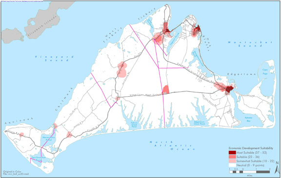
Island-wide map created for the economic section of the Community Development Plan of 2004. | community development plan | Planning Project | October 27, 2006 | All-Island |
|
|
Other | July 9, 2004 | |||
|
|
Catch basin locations were GPSed by the MVC. The general storm water pipeline system is also mapped. This map is formatted for an 8x11 page. | Planning Project | January 7, 2015 | Tisbury (Vineyard Haven) | |
|
|
Map showing NHESP Priority Habitats of Rare Species and NHESP Estimated Habitats of Rare Wildlife. These data are effective as of Oct. 1, 2006. | Other | October 4, 2006 | Gosnold | |
|
|
Map compiled in Feb. 2015 using MassDOT/MassGIS roads data from 2014. All roads in Aquinnah are labeled with street name and a look-up table with street name and index location is provided. | Other | February 3, 2015 | Aquinnah (Gay Head) | |
|
|
NHESP (Natural Heritage and Endangered Species Program) data layers for Priority Habitats of rare species and Estimated Habitats of rare wildlife. Data effective as of 2008 (latest available as of July 2012). | Other | July 26, 2012 | Gosnold | |
|
|
Edgartown map created for the open space & natural resources section of the Community Development Plan of 2004. | community development plan | Planning Project | October 23, 2006 | Edgartown |
|
|
PDM Aquinnah FIRM map | Other | January 14, 2014 | Aquinnah (Gay Head) | |
|
|
James Pond water quality sampling stations for resource assessment during 2005 | mv coastal pond water quality survey- summer 2005 | Planning Project | June 22, 2007 | West Tisbury |
|
|
Environmental Sensitivity Index Map Squibnocket Quadrangle | sensitivity of coastal environments and wildlife to spilled oil | Planning Project | February 25, 2005 | Aquinnah (Gay Head) |
|
|
Edgartown map created for the economic suitability section of the Community Development Plan of 2004. | community development plan | Planning Project | October 23, 2006 | Edgartown |
|
|
CR 3 - 2011 Goodale Pit NHESP Maps | goodale pit | DRI | May 20, 2011 | Oak Bluffs |
|
|
PDM Tisbury Sea Level Rise | pdm | Planning Project | January 8, 2014 | Tisbury (Vineyard Haven) |
|
|
Island-wide map created for the housing section of the Community Development Plan of 2004. | community development plan | Planning Project | October 27, 2006 | All-Island |
|
|
Other | July 9, 2004 |
Pages
Office location:
Office location:
The Stone Building
33 New York Avenue
Oak Bluffs, MA 02557
Telephone: 508-693-3453
Fax: 508-693-7894
Mailing Address
Mailing address:
Martha's Vineyard Commission
P.O. Box 1447
Oak Bluffs, MA 02557
About the MVC
Site Map
Copyright
© 2008 - 2026
Martha's Vineyard Commission
All Rights Reserved