Maps
| Name | Description | Project | Project Type | Document Date | Town |
|---|---|---|---|---|---|
|
|
Zoning Map of Gosnold (Cuttyhunk), MA. PDF format 11x17 page size, full color. Map compiled in Nov. 2015. See the town by-law for more details. This map is for planning purposes only and not for regulatory interpretation. | zoning maps | Other | November 10, 2015 | Oak Bluffs |
|
|
Zoning Map of West Tisbury, MA. PDF format 11x17 page size, full color. Map compiled in July 2015. See the town by-law for more details. This map is for planning purposes only and not for regulatory interpretation. | Other | July 28, 2015 | ||
|
|
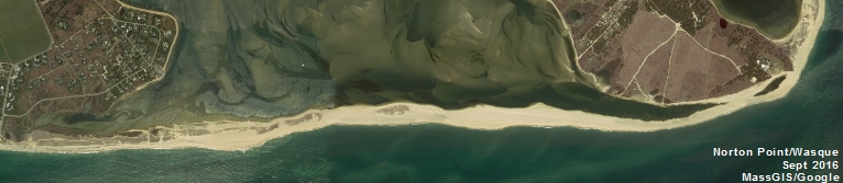
10" by 2" image of Wasque shoreline from April of 2014. The aerial image is compliments of MassGIS/USGS. | Other | May 6, 2015 | ||
|
|
The staff of the MVC have been periodically GPSing the cliff and tide line along Wasque (Chappy/Edgartown) since June of 2012 to document the changing shoreline in this dynamic area. This latest map series shows the GPSed cliff and tide line from April 23, 2015 along with GPSed tracklines from several of the previous visits. The underlying aerial photo is from 2011. The MVC uses a Trimble GeoXH GPS unit which is quoted as having sub-foot accuracy. | Other | April 29, 2015 | ||
|
|
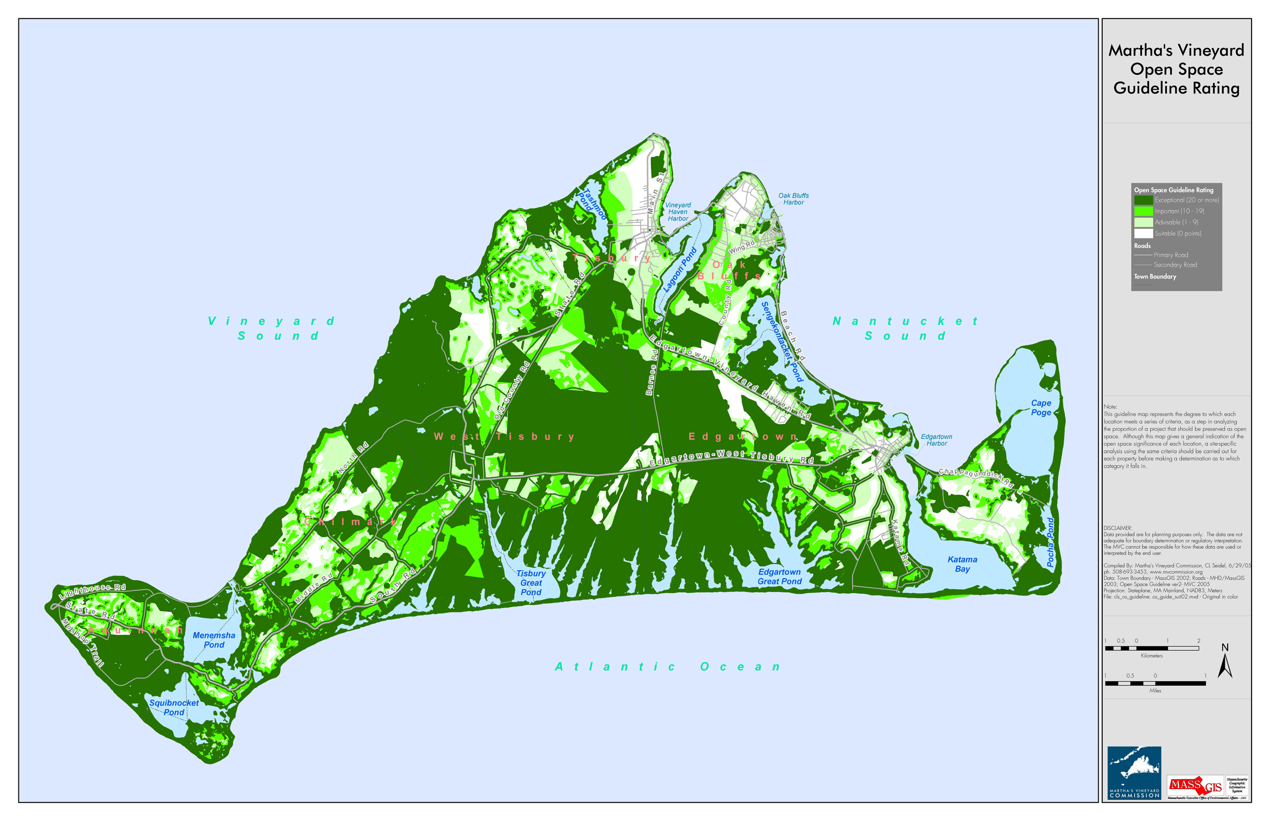
Based on various criteria, areas of MV were categorized to indicate areas ideal for open space preservation. Areas are categorized as either Suitable, Advisable, Important, or Exceptional (exceptional being the most ideal of open space preservation). | open space guideline | Planning Project | July 30, 2010 | All-Island |
|
|
DRI 597 Middle Line - Chilmark Open Space | middle line housing | DRI | November 14, 2006 | Chilmark |
|
|
Map showing proposed SUP from Wind's Up to Saltwater Restaurant | Planning Project | September 14, 2012 | All-Island | |
|
|
PDM Chilmark Wildland-Urban Interface map | Planning Project | January 14, 2014 | Chilmark | |
|
|
land uses in the zone II for Tisbury | m.v. source water protection project | Planning Project | October 4, 2004 | Edgartown |
|
|
Water Resource Assessment Stations - Pocha Pond - for sampling year 2004 | Other | October 18, 2006 | Edgartown | |
|
|
Island-wide map created for the housing section of the community development plan of 2004. | community development plan | Planning Project | October 27, 2006 | All-Island |
|
|
Hurricane inundation areas overlayed on parcel boundaries and aerial photo from 2009. | Other | August 26, 2011 | Tisbury (Vineyard Haven) | |
|
|
The hurricane surge inundation areas shown on this map depict the inundation that can be expected to result from a worst case combination of hurricane landfall location, forward speed, and direction for each hurricane category. | Other | July 5, 2013 | Chilmark | |
|
|
DRI 560 M2 Bridge Housing Site Utilities Layout | bridge housing | DRI | November 30, 2007 | Tisbury (Vineyard Haven) |
|
|
PDM Oak Bluffs Wildfire map | Other | January 14, 2014 | Oak Bluffs |
Pages
Office location:
Office location:
The Stone Building
33 New York Avenue
Oak Bluffs, MA 02557
Telephone: 508-693-3453
Fax: 508-693-7894
Mailing Address
Mailing address:
Martha's Vineyard Commission
P.O. Box 1447
Oak Bluffs, MA 02557
About the MVC
Site Map
Copyright
© 2008 - 2025
Martha's Vineyard Commission
All Rights Reserved