Maps
| Name | Description | Project | Project Type | Document Date | Town |
|---|---|---|---|---|---|
|
|
PDM West Tisbury Sea Level Rise map PDM Pre Disaster Mitigation Pre-Disaster Mitigation | Other | January 14, 2014 | West Tisbury | |
|
|
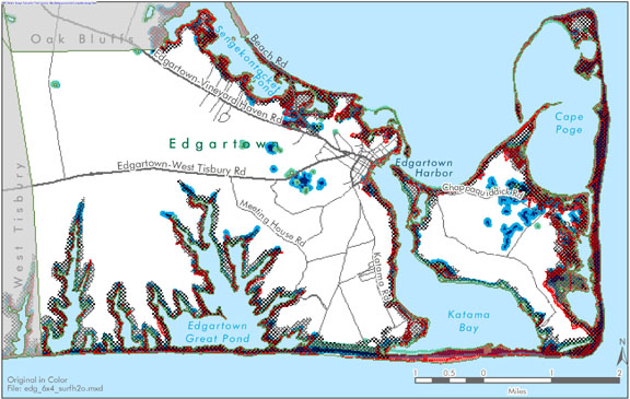
Edgartown map created for the Open Space and Natural Resources section of the Community Development Plan of 2004. | community development plan | Planning Project | October 27, 2006 | Edgartown |
|
|
Tashmoo Pond water quality sampling stations for resource assessment during 2005 | mv coastal pond water quality survey- summer 2005 | Planning Project | June 22, 2007 | Tisbury (Vineyard Haven) |
|
|
Parcels (as of 2008) overlaid on FEMA's 100 year and 500 year flood zones (as of 2010). | Other | February 7, 2013 | Tisbury (Vineyard Haven) | |
|
|
Environmental Sensitivity Index Map Squibnocket Quadrangle | sensitivity of coastal environments and wildlife to spilled oil | Planning Project | February 25, 2005 | Aquinnah (Gay Head) |
|
|
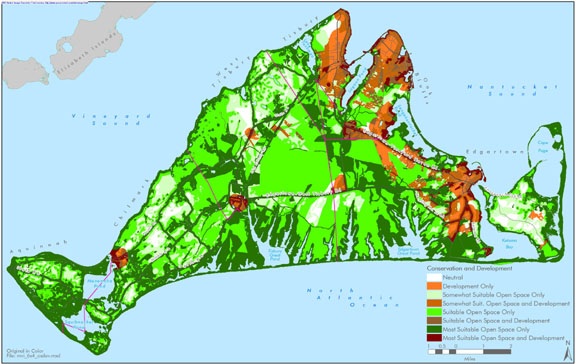
The Land Use Guidance Map is a product from the Island Plan published in 2009 by the MVC. Through a series of analyses, 6 key maps were combined to produce the guidance map (Natural Resources, Water Resources, Haz. Mitigation, Built Envrironment, Housing Development, and Economic Development). The Guidance Map identifies which areas are most appropriate for additional development and in which it is preferable to limit the amount of development and/or preserve land as open space. | island plan | Other | October 24, 2012 | All-Island |
|
|
PDM Edgartown FIRM map | Other | January 14, 2014 | Edgartown | |
|
|
Edgartown map created for the existing conditions section of the Community Development Plan of 2004. | community development plan | Planning Project | October 23, 2006 | Edgartown |
|
|
Island-wide map created for the development section of the Community Development Plan of 2004. | community development plan | Planning Project | October 27, 2006 | All-Island |
|
|
The map displays the water resource assessment stations in Oyster Pond where water quality samples were collected during 2006. | mv water quality survey: summer 2006 | Planning Project | July 14, 2008 | Edgartown |
|
|
Other | July 9, 2004 | |||
|
|
Hurricane inundation areas overlayed on parcel boundaries and aerial photo from 2009. | Other | August 26, 2011 | Chilmark | |
|
|
The hurricane surge inundation areas shown on this map depict the inundation that can be expected to result from a worst case combination of hurricane landfall location, forward speed, and direction for each hurricane category. | Other | July 5, 2013 | Gosnold | |
|
|
Map showing NHESP Priority Habitats of Rare Species and NHESP Estimated Habitats of Rare Wildlife. These data are effective as of Oct. 1, 2006. | Other | October 4, 2006 | Gosnold | |
|
|
PDM West Tisbury Wildfire map | Other | January 14, 2014 | West Tisbury | |
|
|
Edgartown map created for the Open Space and Natural Resources section of the Community Development Plan of 2004. | community development plan | Planning Project | October 27, 2006 | Edgartown |
|
|
Edgartown map created for the open space and recreation section of the community development plan of 2004. | community development plan | Planning Project | October 27, 2006 | Edgartown |
|
|
MVC Meeting 9/20 - Map to O B Sr. Center | Other | September 18, 2007 | ||
|
|
Parcels (as of 2008) overlaid on FEMA's 100 year and 500 year flood zones (as of 2010). | Other | February 7, 2013 | West Tisbury | |
|
|
Vineyard Bike Path Network Map | bike path map | Planning Project | May 10, 2005 | All-Island |
Pages
Office location:
Office location:
The Stone Building
33 New York Avenue
Oak Bluffs, MA 02557
Telephone: 508-693-3453
Fax: 508-693-7894
Mailing Address
Mailing address:
Martha's Vineyard Commission
P.O. Box 1447
Oak Bluffs, MA 02557
About the MVC
Site Map
Copyright
© 2008 - 2026
Martha's Vineyard Commission
All Rights Reserved